Major Storm Brings Winter
Weather To The NWS Pleasant Hill Office
|
The major winter storm that affected portions of
the southern plains and midwest brought winter weather to the
National Weather Service office in Pleasant Hill, MO. The event
began on November 29th with the office receiving a coating of
approximately 1/8 inch of ice due to periods of freezing rain and
sleet. A brief break from the precipitation during the morning hours
of November 30th was then followed by significant snow fall at the
office during the afternoon and through the overnight hours. The
official snowfall amount at the NWS office was 8.8 inches with a
liquid equivalent of 0.6 inches. Following are pictures taken at the
office during the event as well as after the event on the morning of
Dec 1st. |
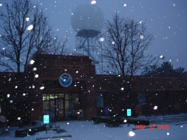
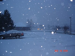
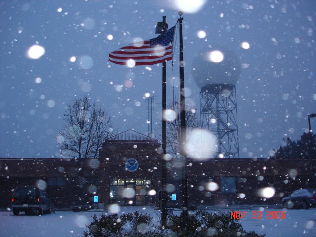
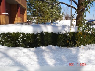
Snowfall during the evening of Nov 30, 2006
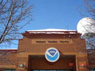
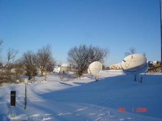
The morning of Dec 1, 2006
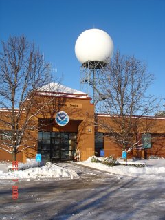
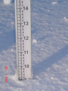
Nearly 9 inches of snow officially measured
at the NWS office
.jpg)
For more information on this recent winter storm click on
the following links:
Nov. 29, 2006 Ice Storm
Nov. 30, 2006 Winter
Weather
Local Storm Report Summary
November 29, 2006 Ice Storm Totals
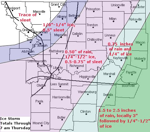
The recent warm weather the area has been
experiencing quickly came to an end on Wednesday. A strong arctic cold
front swept through the region, bringing a wintry mixture of rain, freezing
rain, sleet, and snow to many portions of eastern
Kansas and western
Missouri. As
the cold air surged southward during the day on Wednesday, rain which had
been falling through a warm layer in the atmosphere, quickly changed to
freezing rain and sleet as it reached the cold air near the surface.
While this rainfall quickly changed over to a wintry mix in areas north and
west of a line from Butler
to Marshall and Kirkville, areas to the south of this line received copious
amounts of rainfall. Rainfall reports from cooperative observers in these
areas reported just over 3 inches of rain in Boonville, while rainfall
amounts in both
Macon and Sedalia approached 2 inches. This rain not only
caused streams and rivers to rise to near flood stage, but hazardous road
conditions resulted overnight once cold air finally reached the area. Most
areas received light ice amounts near 1/8"; however some areas in Pettis and
Cooper counties received 1/4"-3/8" of ice accumulations.
Farther to the northwest rain quickly changed into freezing rain and sleet
by the afternoon. After receiving an additional quarter to half inch of
rainfall in the morning, areas from Paola to the Kansas City Metro, Chillicothe, and Unionville received the
heaviest of the freezing precipitation. After many areas picked up a quick
1/4"-1/2" of ice accumulations, many areas also received up to a half an
inch of sleet accumulations. Fortunately, freezing rain and sleet quickly
ended by 10 pm, limiting the extent of the hazardous road conditions while
allowing road crews to quickly dispatch troubled areas of roadways.
Even farther northwest across areas from St. Joseph, to Tarkio, and
Maryville only a light coating of freezing rain was received, with many
areas experiencing just a trace of sleet. For further information on the
first half of our potent winter storm system, feel free to browse the latest
winter weatherand observational products, including our
current storm summary page.
|
November 30, 2006
Winter Storm Summary
A very strong upper level system
tracked from southern Oklahoma into southeast Missouri during the
overnight hours of November 30th. As this storm pushed through the
Midwest, it not only produced copious amounts of rain and ice on the
29th of November, but also record snow amounts over portions of the
area on the 30th.
After all was said and done
by Friday morning, total snow accumulations exceeded 12 inches south of
a line from Paola, Kansas to Warrensburg,
Missouri line and Macon. Even deeper snow accumulations were found from
Butler, MO, through Clinton, Sedalia, and Boonville, where snow amounts
pushed 16 inches. In fact, a whopping 18 inches of snow was reported in
the cities of Clinton and Butler.
Snowfall across the Kansas City
Metropolitan area varied considerably from north to south. Areas in the
vicinity of the Kansas City International Airport received only a
dusting of snow whereas, the extreme southern portions of Johnson County
Kansas and Jackson County Missouri received upwards of 10 inches of
snow. Extreme northwest Missouri and northeast Kansas escaped the heavy
snowfall, with no snow accumulations whatsoever.
|
Higher snowfall totals
from across the area:
Clinton, MO - 18"
Butler, MO - 18"
Blairstown, MO - 18"
Sedalia, MO - 16"
Moberly, MO - 15"
Boonville, MO - 15" |
For a complete
list of snow totals visit the
Local Storm Report Summary.
|
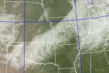
Snow
swath evident from the southern plains to the midwest on visible
satellite imagery during the morning of Dec 1, 2006. |
For more information on
this winter weather event, please click on the links below:
November 29, 2006 Ice Storm
NWS Pleasant Hill Office Experiences Nov 30, 2006
Storm
|
|
Surrounding Radars |
 |
 |
 |
 |
| Kansas City, MO |
Topeka, KS |
Springfield, MO |
St. Louis, MO |
|
Latest Local Storm Report |
000
NWUS53 KEAX 312346
LSREAX

PRELIMINARY LOCAL STORM REPORT...SUMMARY
NATIONAL WEATHER SERVICE KANSAS CITY/PLEASANT HILL MO
546 PM CST SUN DEC 31 2006

..TIME...   ...EVENT...      ...CITY LOCATION...     ...LAT.LON...
..DATE...   ....MAG....      ..COUNTY LOCATION..ST.. ...SOURCE....
            ..REMARKS..

0100 PM     SNOW             ROCKPORT                40.42N 95.52W
12/31/2006  E1.0 INCH        ATCHISON           MO   LAW ENFORCEMENT

            SHERIFF OFFICE REPORTS THEY HAVE HAD SOME SLIDE OFFS ON
            THE INTERSTATE.

0256 PM     SNOW             ROCKPORT                40.42N 95.52W
12/31/2006  E1.5 INCH        ATCHISON           MO   LAW ENFORCEMENT

0300 PM     SNOW             2 SW ROCKPORT           40.40N 95.54W
12/31/2006  E3.0 INCH        ATCHISON           MO   TRAINED SPOTTER

            GRASSY SURFACES

0300 PM     SNOW             ROCKPORT                40.42N 95.52W
12/31/2006  E1.0 INCH        ATCHISON           MO   TRAINED SPOTTER

0416 PM     SNOW             TARKIO                  40.44N 95.38W
12/31/2006  E1.5 INCH        ATCHISON           MO   LAW ENFORCEMENT

            AROUND 1.5 INCHES OF SNOW WITH SEVERAL VEHICLES HAVING
            SLID OFF CITY STREETS.

0448 PM     SNOW             TROY                    39.79N 95.09W
12/31/2006  E1.0 INCH        DONIPHAN           KS   LAW ENFORCEMENT

0453 PM     SNOW             CRAIG                   40.19N 95.37W
12/31/2006  E2.0 INCH        HOLT               MO   TRAINED SPOTTER

            1 TO 2 INCHES REPORTED.

0456 PM     SNOW             BURLINGTON JCT          40.45N 95.07W
12/31/2006  E1.0 INCH        NODAWAY            MO   TRAINED SPOTTER

0458 PM     SNOW             6 N FILLMORE            40.11N 94.97W
12/31/2006  E0.5 INCH        ANDREW             MO   TRAINED SPOTTER

0500 PM     SNOW             SAVANNAH                39.94N 94.83W
12/31/2006  E0.5 INCH        ANDREW             MO   LAW ENFORCEMENT


&&

$$

GAMIS
|
|
Winter Preparation Tips |
|
Be prepared for
the upcoming winter season by visiting the following websites which
provide plenty of safety and preparation tips for the cold weather
season:
Additional Links for Winter Weather Preparedness
NWS - Winter Weather Page
American Red Cross
FEMA
Missouri State Emergency
Management Agency |
| |
Local Storm Report
Issued by NWS Kansas City/Pleasant Hill, MO
000
NWUS53 KEAX 312346
LSREAX
PRELIMINARY LOCAL STORM REPORT...SUMMARY
NATIONAL WEATHER SERVICE KANSAS CITY/PLEASANT HILL MO
546 PM CST SUN DEC 31 2006
..TIME... ...EVENT... ...CITY LOCATION... ...LAT.LON...
..DATE... ....MAG.... ..COUNTY LOCATION..ST.. ...SOURCE....
..REMARKS..
0100 PM SNOW ROCKPORT 40.42N 95.52W
12/31/2006 E1.0 INCH ATCHISON MO LAW ENFORCEMENT
SHERIFF OFFICE REPORTS THEY HAVE HAD SOME SLIDE OFFS ON
THE INTERSTATE.
0256 PM SNOW ROCKPORT 40.42N 95.52W
12/31/2006 E1.5 INCH ATCHISON MO LAW ENFORCEMENT
0300 PM SNOW 2 SW ROCKPORT 40.40N 95.54W
12/31/2006 E3.0 INCH ATCHISON MO TRAINED SPOTTER
GRASSY SURFACES
0300 PM SNOW ROCKPORT 40.42N 95.52W
12/31/2006 E1.0 INCH ATCHISON MO TRAINED SPOTTER
0416 PM SNOW TARKIO 40.44N 95.38W
12/31/2006 E1.5 INCH ATCHISON MO LAW ENFORCEMENT
AROUND 1.5 INCHES OF SNOW WITH SEVERAL VEHICLES HAVING
SLID OFF CITY STREETS.
0448 PM SNOW TROY 39.79N 95.09W
12/31/2006 E1.0 INCH DONIPHAN KS LAW ENFORCEMENT
0453 PM SNOW CRAIG 40.19N 95.37W
12/31/2006 E2.0 INCH HOLT MO TRAINED SPOTTER
1 TO 2 INCHES REPORTED.
0456 PM SNOW BURLINGTON JCT 40.45N 95.07W
12/31/2006 E1.0 INCH NODAWAY MO TRAINED SPOTTER
0458 PM SNOW 6 N FILLMORE 40.11N 94.97W
12/31/2006 E0.5 INCH ANDREW MO TRAINED SPOTTER
0500 PM SNOW SAVANNAH 39.94N 94.83W
12/31/2006 E0.5 INCH ANDREW MO LAW ENFORCEMENT
&&
$$
GAMIS